
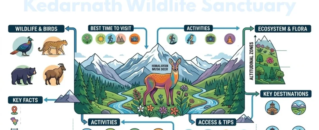
Kedarnath Wildlife Sanctuary is a spectacular protected region in Uttarakhand, known for its rich Himalayan biodiversity, dramatic mountains, dense forests, and peaceful alpine landscapes. Established in 1972, it provides an important habitat for the Himalayan musk deer and many other mountain species. The sanctuary also supports diverse Himalayan wildlife, colorful birds, rare plants, and high-altitude ecosystems. Its location near Kedarnath, Chopta, and Tungnath makes it appealing to travelers interested in nature, trekking, photography, and spirituality. From forested valleys to open alpine meadows, every part of the region offers a different experience. Whether you are planning a trek or exploring Uttarakhand’s natural beauty, this sanctuary is worth discovering.
What Is Kedarnath Wildlife Sanctuary?
Established in 1972, Kedarnath Wildlife Sanctuary covers approximately 975.20 square kilometers in the Garhwal Himalayas. Its elevation ranges from around 1,160 meters to more than 7,000 meters, creating several distinct climatic and ecological zones within the protected area.
The sanctuary was created to protect the rich Himalayan ecosystem and important species such as the Himalayan musk deer. Because of its enormous elevation range, the landscape changes from temperate forests at lower levels to sub-alpine vegetation and alpine meadows at higher elevations.
Where Is Kedarnath Wildlife Sanctuary Located?
The Kedarnath Wildlife Sanctuary is situated in the northern part of Uttarakhand and extends across the districts of Chamoli and Rudraprayag. Rather than being a small wildlife park with one entrance, it covers a huge mountainous region containing valleys, forests, lakes, bridges, rivers, meadows, and high-altitude terrain.
The sanctuary is associated with the upper catchments of the Alaknanda and Mandakini river systems. Its surrounding Himalayan landscape includes prominent peaks and mountain valleys, making the region important for both biodiversity and water resources.
Must Read: Rock Garden Timings
Kedarnath Wildlife Sanctuary: Quick Facts
| Feature | Details |
| Location | Uttarakhand, India |
| Districts | Chamoli and Rudraprayag |
| Established | 1972 |
| Approximate area | 975.20 sq km |
| Elevation | About 1,160–7,068 m |
| Landscape | Himalayan forests, valleys, alpine meadows and high mountains |
| Famous species | Himalayan musk deer |
| Major rivers | Alaknanda and Mandakini systems |
| Main attractions | Wildlife, trekking, birdwatching, nature and pilgrimage |
| Nearby destinations | Kedarnath, Chopta, Tungnath and Chandrashila |
These factors also explain why a trip to the sanctuary can feel very different from a conventional wildlife excursion. Visitors may pass through several vegetation zones and experience significant changes in temperature, scenery, and terrain during the same journey.
Why Is Kedarnath Wildlife Sanctuary Famous?
The Kedarnath Wildlife Sanctuary is best known for its Himalayan biodiversity and its association with the endangered Himalayan musk deer. Its protected forests and high-altitude habitats provide shelter for a wide range of mammals, birds, reptiles, butterflies, fish, and plant species.
Its fame also comes from its location within one of Uttarakhand’s most scenic travel regions. The combination of Kedarnath pilgrimage routes, Chopta’s mountain landscapes, Tungnath trekking, alpine meadows, and wildlife habitat gives the area much broader appeal than a destination focused only on animal viewing.
Must Read: Karimnagar Deer Park
Wildlife in Kedarnath Sanctuary
The Himalayan musk deer is one of the most important animals associated with the sanctuary. This small and elusive mountain mammal generally inhabits steep forested and high-altitude environments, so spotting one in the wild requires patience and luck.
Other wildlife associated with the region includes the Himalayan black bear, leopard, Himalayan tahr, goral, barking deer, and other mountain species. Higher and more remote habitats can also support cold-adapted species such as the snow leopard.
Wildlife sightings are never guaranteed. Travelers should avoid approaching animals, making loud noises, feeding wildlife, or leaving food on trails. Keeping a respectful distance is essential for both visitor safety and animal welfare.
Must Read: Tenneti Park Beach
Birds of the Sanctuary
The bird sanctuary is also an important destination for Himalayan birdwatching. Its changing elevation, forest types, alpine zones, and river valleys create habitats for a remarkable variety of bird species.
The Himalayan monal is among the most recognizable birds associated with Uttarakhand’s mountain forests. Other pheasants, raptors, Himalayan songbirds, and high-altitude species may also be encountered depending on the season and location.
Birdwatchers will generally have a better experience by visiting quieter areas during the early morning. Binoculars and a camera with a suitable zoom lens are preferable to getting close to birds or disturbing their natural behavior.
Must Read: Dehradun Zoo Timing
Flora of Kedarnath Wildlife Sanctuary
The plant diversity is one of the most impressive aspects of the sanctuary. More than 1,100 plant species have been recorded in the protected landscape, with vegetation changing according to altitude, temperature, rainfall, and soil conditions.
Lower and middle elevations contain Himalayan forest communities featuring oak, pine, rhododendron, birch, and other trees. As the elevation increases, forests gradually give way to sub-alpine vegetation and open alpine meadows.
These different habitats are not simply scenic backgrounds. They provide food, shelter, breeding grounds, and migration corridors for wildlife, making plant conservation an important part of protecting the wider Himalayan ecosystem.
Alpine Meadows and Himalayan Landscape
The high-altitude meadows are among the most visually striking features of the region. Locally known as bugyals in several parts of Uttarakhand, these open grasslands contrast dramatically with the dense forests found at lower elevations.
During suitable seasons, alpine flowers and green vegetation can transform these areas into colorful mountain landscapes. However, fragile high-altitude ecosystems can recover slowly from damage, so visitors should avoid trampling vegetation or leaving designated trails.
The surrounding mountains, deep valleys, snow-covered peaks, streams, and changing cloud formations also make the region attractive for landscape photography and nature observation.
Kedarnath and the Wildlife Sanctuary
The relationship between Kedarnath and the protected landscape is one of the main reasons travelers search for information about the sanctuary. The famous Kedarnath pilgrimage takes visitors into a high-altitude Himalayan environment where protected forests and mountain habitats form part of the surrounding landscape.
The Kedarnath route begins from Gaurikund and continues through rugged mountain terrain toward the temple. The wider region therefore combines religious travel with opportunities to observe Himalayan landscapes, vegetation, and wildlife habitats.
Travelers should remember that a pilgrimage route is not automatically a wildlife-viewing trail. The primary goal should be to follow the designated route safely while respecting the protected environment.
Must Read: Muramalla Temple
Chopta, Tungnath and Chandrashila Connection
Chopta is one of the most popular mountain destinations associated with this wider Himalayan region. It is known for forests, meadows, mountain views, and its position as a starting point for the Tungnath and Chandrashila trek.
Tungnath is one of the Panch Kedar temples and sits at a high elevation, while Chandrashila provides expansive Himalayan views beyond Tungnath. These destinations are particularly appealing to travelers who want to combine nature, trekking, photography, and spirituality.
Because these places are spread across mountainous terrain, they should not be treated as though they are all located at one compact tourist site. Travel time, road conditions, altitude, and trekking requirements vary considerably.
Panch Kedar and the Sanctuary Region
The wider landscape is closely connected with the Panch Kedar pilgrimage tradition. Kedarnath, Tungnath, Rudranath, Madhyamaheshwar, and Kalpeshwar form this important group of Shiva temples in the Garhwal Himalayas.
This connection gives the region a distinctive combination of cultural and natural significance. Travelers can encounter ancient pilgrimage traditions while moving through forests, valleys, alpine meadows, and high mountain terrain.
Those planning a multi-destination trip should allow sufficient time for each route rather than attempting to cover every destination in a rushed itinerary.
Trekking and Outdoor Activities
Trekking is one of the most rewarding ways to experience the Himalayan environment around the sanctuary. Depending on the route, travelers can encounter forest trails, mountain streams, alpine meadows, steep climbs, temple paths, and panoramic viewpoints.
Popular trekking destinations in the wider region include Kedarnath, Tungnath, Chandrashila, Madhyamaheshwar, Rudranath, and other high-altitude routes. Each trek has different difficulty levels and seasonal conditions.
Besides trekking, visitors can enjoy birdwatching, landscape photography, nature observation, camping where permitted, and quiet walks through suitable areas. Wildlife observation should always remain low-impact and follow local regulations.
Must Read: NTR Gardens
Best Time to Visit Kedarnath Wildlife Sanctuary
The best time depends on your route, altitude, and travel purpose. Spring and early summer can provide pleasant conditions in many lower and middle-altitude areas, while post-monsoon months are often attractive for clearer mountain views and trekking.
The monsoon season can bring heavy rainfall, slippery trails, landslides, and disruptions on mountain roads. Higher elevations can also experience rapidly changing weather, making flexible travel plans important.
Winter brings snowfall to many high-altitude areas and can make some trekking routes difficult or inaccessible. Travelers planning a winter journey should verify current road, trail, weather, and accommodation conditions before departure.
Month-by-Month Travel Conditions
| Period | Typical Conditions | Suitable For |
| March–April | Spring conditions, improving weather | Nature, lower-altitude travel |
| May–June | Generally favorable before peak monsoon | Trekking, pilgrimage, sightseeing |
| July–August | Rain, slippery trails and possible disruptions | Limited travel with caution |
| September–October | Clearer skies and pleasant mountain conditions | Trekking, photography, sightseeing |
| November | Cooler weather with changing conditions | Quiet mountain travel |
| December–February | Cold and snowfall at higher elevations | Snow experiences where accessible |
Weather can vary significantly between valleys and high-altitude routes. Therefore, these seasonal patterns should be treated as general guidance rather than a guarantee of conditions on a particular day.
How to Reach Kedarnath Wildlife Sanctuary
Because the protected area covers nearly 1,000 square kilometers, there is no single road or entrance that takes every traveler into the sanctuary. Your route depends on whether you are visiting Kedarnath, Chopta, Tungnath, or another destination within the wider region.
For Kedarnath, travelers commonly reach Gaurikund by road before continuing on foot along the pilgrimage route. Chopta and other mountain destinations are approached through different road networks, with trekking required for some attractions.
Travelers arriving from major cities generally use Dehradun, Rishikesh, Haridwar, or other Uttarakhand transport hubs before continuing toward the relevant mountain gateway. Road conditions can change because of rain, snowfall, landslides, and maintenance, so current local information should always be checked before departure.
Nearest Railway and Airport Options
For visitors traveling from outside Uttarakhand, railway and air connections are generally used only for reaching a nearby transport hub before continuing by road.
Dehradun’s Jolly Grant Airport is the main airport serving much of the Garhwal region, while railway travelers commonly use stations such as Haridwar or Rishikesh before continuing toward the mountains.
The final journey usually takes considerably longer than the distance on a map suggests because of winding Himalayan roads, traffic, weather, and terrain. Building extra travel time into the itinerary is therefore a practical choice.
Places to Visit Near the Sanctuary
The wider region contains several destinations that can be combined with a wildlife and nature-focused journey. Kedarnath is the major pilgrimage attraction, while Chopta, Tungnath, and Chandrashila are popular for trekking and Himalayan scenery.
Travelers interested in the Panch Kedar tradition can also explore Madhyamaheshwar, Rudranath, and Kalpeshwar. Triyuginarayan is another culturally significant destination in the broader region.
Rather than trying to visit everything in one trip, it is better to group destinations according to location and route. This reduces unnecessary travel and allows more time to experience each mountain area.
Must Read: Ujjain Places to Visit
Entry, Permits and Local Regulations
Protected-area regulations can vary depending on the location, activity, route, season, and current forest department requirements. Camping, trekking, photography, vehicle access, and other activities may be subject to specific rules.
Visitors should verify current requirements before traveling rather than relying on an old fee, permit rule, or timetable found online. Considering your budget in advance can also help you plan expenses more effectively. Carrying valid identification and following instructions from local officials can make the journey smoother.
The most important rule is to treat the area as a protected ecosystem. Do not litter, feed animals, damage plants, collect wildlife or natural objects, or disturb other visitors and local communities.
Responsible Wildlife Tourism
Responsible tourism is particularly important in a protected Himalayan habitat. Even apparently harmless actions, such as playing loud music, chasing an animal for a photograph, or leaving food behind, can disturb wildlife.
Stay on permitted trails, carry waste back with you, avoid single-use plastic where possible, and never attempt to touch or attract wild animals. Keep voices low in forest areas and allow birds and mammals to move naturally.
Supporting local guides, transport providers, homestays, and other community-based services can also help distribute tourism benefits across mountain communities while creating a more meaningful travel experience.
Photography and Birdwatching Tips
The sanctuary region offers excellent opportunities for landscape photography because the scenery changes rapidly with altitude. Forests, rhododendron blooms, alpine meadows, ridges, valleys, temples, and distant Himalayan peaks can all create memorable photographs.
Wildlife photography requires a different approach. Use a zoom lens or binoculars whenever possible and avoid moving closer simply to obtain a better photograph. For birds, early mornings are often productive because activity can be higher and trails may be quieter.
Photography should never take priority over safety or conservation. Do not enter restricted areas, block trails, use loud equipment, or disturb animals to create a photograph.
Must Read: Vemulawada Temple
What to Pack for the Journey
Mountain weather can change quickly, so travelers should prepare for more than one type of weather. Warm layers, a waterproof outer layer, comfortable trekking shoes, a reusable water bottle, sun protection, basic medicines, and a small first-aid kit are useful.
For higher-altitude routes, travelers should also consider gloves, thermal clothing, sunglasses, sunscreen, and a headlamp. Keep luggage manageable because some routes require substantial walking or trekking.
Avoid overpacking while making sure essential items are available. Access to shops and medical facilities becomes more limited as you move deeper into remote mountain areas.
Altitude and Safety Tips
Altitude is an important consideration for visitors traveling from lowland cities to high Himalayan destinations. The body needs time to adjust, particularly when the itinerary involves rapid gains in elevation.
Walk at a comfortable pace, stay hydrated, take sufficient rest, and avoid pushing yourself if you feel unwell. Symptoms such as severe headache, unusual breathlessness, confusion, or worsening nausea should not be ignored.
Weather is another major safety factor. Rain, snow, fog, strong winds, and landslides can affect mountain travel with little warning. Checking current conditions and listening to local authorities is essential before beginning a trek.
Why Visit This Himalayan Sanctuary?
The biggest attraction is not a single viewpoint or one guaranteed wildlife encounter. It is the opportunity to experience an enormous Himalayan ecosystem where forests, rivers, alpine meadows, wildlife, temples, trekking routes, and mountain communities exist within the same broad landscape.
For nature lovers, the region offers biodiversity and scenery. For trekkers, it provides challenging mountain routes. For pilgrims, it offers access to important temples. For photographers and birdwatchers, changing habitats provide a rich natural setting.
This combination makes the destination particularly valuable for travelers who want to experience Uttarakhand beyond conventional sightseeing.
Must Read: Dharampur
Conclusion
Kedarnath Wildlife Sanctuary offers a rare combination of Himalayan wildlife, diverse forests, alpine meadows, dramatic landscapes, trekking routes, and spiritual heritage. From the Himalayan musk deer and colorful mountain birds to Chopta, Tungnath, Kedarnath, and the Panch Kedar region, the destination provides many ways to experience Uttarakhand’s natural and cultural richness. Careful seasonal planning, respect for local regulations, and responsible travel can make a visit safer, more rewarding, and more sustainable.
FAQ’s
What is Kedarnath Wildlife Sanctuary famous for?
Kedarnath Wildlife Sanctuary is famous for its Himalayan biodiversity, particularly the Himalayan musk deer. It is also known for its forests, alpine meadows, birdlife, high-altitude landscapes, and connection with the Kedarnath and Panch Kedar regions.
Where is the sanctuary located?
The protected area lies across parts of Chamoli and Rudraprayag in Uttarakhand. It covers a large mountainous region rather than a single compact tourist attraction.
Is the sanctuary good for wildlife photography?
Yes, the region can be excellent for landscape, bird, and wildlife photography. However, animals should always be photographed from a safe distance without chasing, feeding, calling, or otherwise disturbing them.
How can I reach Kedarnath from the sanctuary region?
Kedarnath is generally approached through Gaurikund, followed by the established trekking route to the temple. Other parts of the sanctuary region, such as areas around Chopta and Tungnath, have different road and trekking access.