
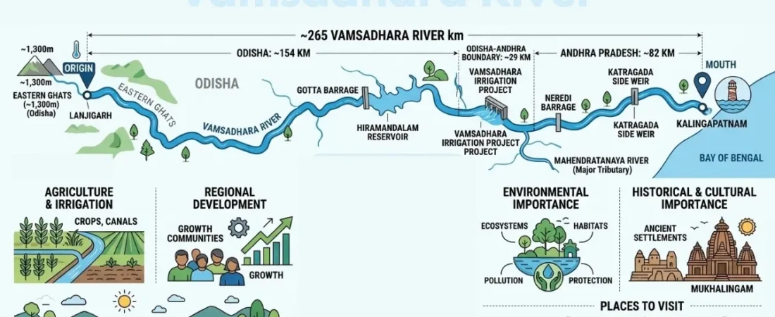
The Vamsadhara River is a remarkable east-flowing river that travels through the scenic landscapes of Odisha and Andhra Pradesh before reaching the Bay of Bengal. Rising in the Eastern Ghats, it supports agriculture, irrigation, and communities across its basin. Along its journey, the river connects to important water resources, major irrigation projects, and historically significant places that reflect the region’s rich heritage. Its course also has a fascinating connection with the Vamsadhara water dispute, involving water-sharing concerns between the two states. From its natural origin to its coastal outlet, this river offers an interesting blend of geography, history, environment, and regional development for travelers, students, and geography enthusiasts.
Vamsadhara River at a Glance
The river originates in southern Odisha and follows an approximately 265-kilometre course toward the Bay of Bengal. According to Central Water Commission material, about 154 km lies in Odisha, around 29 km forms part of the Odisha–Andhra Pradesh boundary, and the remaining section lies in Andhra Pradesh.
| Feature | Details |
| River | Vamsadhara River |
| Origin | Eastern Ghats, Odisha |
| Approximate length | About 265 km |
| Flow direction | Generally eastward |
| States | Odisha and Andhra Pradesh |
| Basin | Vamsadhara River Basin |
| Major tributary | Mahendratanaya River |
| Mouth | Bay of Bengal |
| Important barrage | Gotta Barrage |
| Major reservoir | Hiramandalam Reservoir |
| Important project | Vamsadhara Irrigation Project |
| Major water issue | Odisha–Andhra Pradesh water sharing |
Different publications may report different river lengths because of differences in measurement and the definition of the river’s course. The Central Water Commission figure is a useful reference for a general overview.
Where Does the Vamsadhara River Originate?
The source of the river is in the Eastern Ghats of Odisha, in the region around the border of Kalahandi and Rayagada districts. Central Water Commission material places its origin near Lanjigarh and describes the source area as being at roughly 1,300 metres above sea level.
The mountainous origin is significant because the Eastern Ghats provide the terrain from which numerous streams and rivers descend toward the coastal plains. Seasonal rainfall in the catchment contributes substantially to the river’s flow.
Must Read: Munneru River
Course of the Vamsadhara River
From its source in Odisha, the river generally travels eastward through the Eastern Ghats and adjoining plains. It then forms part of the boundary between Odisha and Andhra Pradesh before continuing through Andhra Pradesh toward the coast.
The river eventually enters the Bay of Bengal near Kalingapatnam. Its course therefore connects an upland catchment with agricultural areas and the coastal environment, giving the basin both geographical and economic importance.
Vamsadhara River Map and Location
A map makes it easier to understand the relationship between the river’s origin, basin, state boundary, irrigation infrastructure, and coastal outlet. The river lies between the Mahanadi and Godavari river systems and forms an important drainage system in southern Odisha and northern Andhra Pradesh.
For travelers and geography enthusiasts, a detailed map can also help identify locations such as Kalingapatnam, Hiramandalam, Mukhalingam, and other places in the wider river region.
Vamsadhara River Basin and Tributaries
The basin extends across parts of Odisha and Andhra Pradesh and receives water from rainfall, smaller streams, and tributaries. Its water resources are particularly important for agriculture and irrigation in areas that depend on regulated supplies.
The Mahendratanaya River is an important tributary associated with the river system. Together, the main river and its tributaries form a connected drainage network that influences agriculture, settlements, and local ecosystems.
Why Is the River Important?
The importance of the Vamsadhara River is closely connected with water availability. Communities in the basin depend on its resources for agriculture, irrigation, domestic needs, and other regional activities.
Its significance has also led to extensive water-management planning. Barrages, canals, reservoirs, and irrigation projects have been developed or proposed to make greater use of the river’s available water while addressing the requirements of both states.
Vamsadhara Irrigation Project
The Vamsadhara irrigation system is one of the most important development efforts associated with the river. Its objective is to use river water for irrigation and support agricultural areas, particularly in Andhra Pradesh and Odisha.
The project has developed through different stages and components, including infrastructure connected with Gotta Barrage and Hiramandalam Reservoir. The wider project history is closely connected with interstate discussions about how the river’s water should be utilized.
Gotta Barrage and Hiramandalam Reservoir
Gotta Barrage is a major water-management structure on the river and is central to discussions about the river’s available yield and sharing between the two states. The Vamsadhara Water Disputes Tribunal later dealt specifically with the yield at Gotta Barrage.
Hiramandalam Reservoir is another important component of the irrigation system. Historical legal proceedings concerning the river also referred to the proposed use of water through a flood-flow canal for storage in the Hiramandalam Reservoir.
Lower Vamsadhara Project and Other Infrastructure
The Lower Vamsadhara Project forms part of the broader effort to develop irrigation from the river. Other infrastructure and proposals associated with the basin include the Neredi Barrage and the side weir at Katragada.
These projects are important because they demonstrate the practical challenges of managing an interstate river. A structure designed to increase irrigation in one area can also raise questions about downstream flow, land requirements, flooding, and water availability in another state.
Vamsadhara River Water Dispute
One of the most significant aspects of the river is the long-running water dispute between Odisha and Andhra Pradesh. The disagreement involves the use, distribution, and control of water from an interstate river and has involved irrigation projects and proposed structures.
The dispute became particularly significant around projects such as the side weir at Katragada and the Neredi Barrage. The Supreme Court’s discussion of the dispute records concerns about the allocation of river water and the potential effect of diversion projects on downstream users.
Vamsadhara Water Disputes Tribunal
The Vamsadhara Water Disputes Tribunal was established to address the interstate dispute. Its proceedings examined questions surrounding water availability, sharing, irrigation projects, and the proposed infrastructure on the river.
The tribunal’s decision declared the yield at Gotta Barrage as 115 TMC and provided for sharing between Odisha and Andhra Pradesh on a 50:50 basis. Official tribunal material also records the issue of the Neredi Barrage and related conditions.
A later publication of the tribunal’s further decision in the Gazette in 2026 states that the final order was published subject to pending Supreme Court proceedings. This is an important distinction when discussing the current legal status rather than presenting older tribunal decisions as the end of every related legal question.
Neredi Barrage and Katragada Side Weir
The Neredi Barrage has been one of the most closely discussed projects in the interstate dispute. The tribunal permitted Andhra Pradesh to construct the barrage, while its decisions also addressed the Katragada side weir and conditions concerning its operation.
The issue is not simply about building a barrage. It involves land requirements, possible upstream effects, irrigation benefits, downstream interests, and mechanisms for supervising the use of the river. Tribunal records also discuss the proposed acquisition of land in Odisha connected with the project.
Water Sharing Between Odisha and Andhra Pradesh
Water sharing is central to the river’s modern history because both states have interests in its waters. Official tribunal material records the principle that the yield at Gotta Barrage is to be shared equally between the two states.
This arrangement needs to be understood alongside the river’s seasonal nature, irrigation requirements, project designs, and legal decisions. Water availability is not simply a fixed quantity throughout the year, making river management a complex combination of hydrology, engineering, agriculture, and law.
Environmental Importance of the River
The river supports aquatic habitats and connects upland landscapes with agricultural and coastal environments. Its basin also contains vegetation, wetlands, streams, and areas that depend on seasonal water availability.
Maintaining river health requires attention to water quality, waste management, riverbank conditions, ecological flows, and sustainable use of water. Large irrigation structures can provide substantial agricultural benefits, but responsible planning also needs to consider environmental and downstream requirements.
Must Read: Kambalakonda Wildlife Sanctuary
Pollution and Conservation Concerns
Like many rivers passing through populated and agricultural landscapes, the river can face pressures from wastewater, solid waste, changes in land use, and alterations to natural flow patterns. These issues can affect water quality and aquatic ecosystems when they are not properly managed.
River conservation therefore involves more than cleaning the waterway. Protecting catchment areas, controlling pollution, maintaining healthy riverbanks, improving wastewater treatment, and using water efficiently are all important parts of long-term river management.
Historical and Cultural Importance
The river region has a strong connection with the cultural history of southern Odisha and northern Andhra Pradesh. Fertile river valleys have historically supported settlements, agriculture, transportation, and communities.
The wider basin also contains important heritage locations. Mukhalingam, in particular, is known for its historic temple complex and provides an opportunity to combine an understanding of the river landscape with the cultural history of the region.
Places to Visit Near the River
The lower river region offers several opportunities for Indian travelers interested in combining nature, history, and coastal landscapes. Kalingapatnam is particularly relevant because of its association with the river’s coastal outlet and the Bay of Bengal.
Mukhalingam is another notable destination for visitors interested in temple architecture and heritage. Hiramandalam and surrounding areas can provide a different perspective, allowing visitors to see the agricultural and irrigation landscape associated with the river basin.
Must Read: Lakaram Lake
Best Time to Explore the Region
The cooler months are generally more comfortable for sightseeing, heritage exploration, and outdoor activities in the wider region. Weather conditions can vary considerably between the upland areas of Odisha and the coastal areas of Andhra Pradesh.
The monsoon can bring greener landscapes and increased river flow, but heavy rainfall may also affect roads and outdoor plans. Checking local weather conditions before traveling is particularly important during periods of heavy rain.
How the River Supports Agriculture
Agriculture is one of the most important beneficiaries of the river’s water resources. Irrigation projects are designed to make water available to cultivated areas and reduce dependence on seasonal rainfall where irrigation networks are available.
The connection between river water and agriculture is also one reason interstate management has become so important. Decisions about reservoirs, barrages, canals, and water withdrawals can directly influence farming communities in both states.
Must Read: Shamirpet Lake
Why the River Matters to Regional Development
The river demonstrates how natural resources and regional development are closely connected. Irrigation infrastructure can improve agricultural productivity and provide more reliable water supplies, while reservoirs and barrages can help regulate seasonal river flows.
At the same time, development needs to account for downstream users, environmental conditions, land requirements, flood risks, Budget considerations, and interstate agreements. Sustainable river management requires these interests to be considered together rather than treating irrigation as an isolated issue.
Vamsadhara River and the Bay of Bengal
The final stage of the river’s journey takes it toward the Bay of Bengal near Kalingapatnam. This creates a geographical connection between the Eastern Ghats, inland agricultural areas, and the coastal environment.
The river’s connection with the sea is also important from an ecological perspective. River systems transport freshwater, sediments, and nutrients toward coastal environments, making the condition of the upstream basin relevant to the health of downstream ecosystems.
Conclusion
The Vamsadhara River is a vital river system linking the Eastern Ghats, Odisha, Andhra Pradesh, agricultural communities, and the Bay of Bengal. Its geography, tributaries, irrigation projects, water-sharing dispute, environmental concerns, and nearby heritage destinations make it far more than a simple geographical feature. Understanding these interconnected aspects provides a complete picture of the river and its continuing importance to the region.
FAQ’s
Where does the Vamsadhara River originate?
The river originates in the Eastern Ghats of Odisha, in the region around the Kalahandi–Rayagada area. The Central Water Commission places the source near Lanjigarh at an elevation of about 1,300 metres.
Which states does the river flow through?
The river flows through Odisha and Andhra Pradesh. A section of its course also forms part of the boundary between the two states.
What is the length of the Vamsadhara River?
The Central Water Commission describes the river as approximately 265 km long. Its course includes sections within Odisha, a shared boundary section, and a section within Andhra Pradesh.
Where does the river meet the Bay of Bengal?
The river flows eastward and reaches the Bay of Bengal near Kalingapatnam in Andhra Pradesh.