
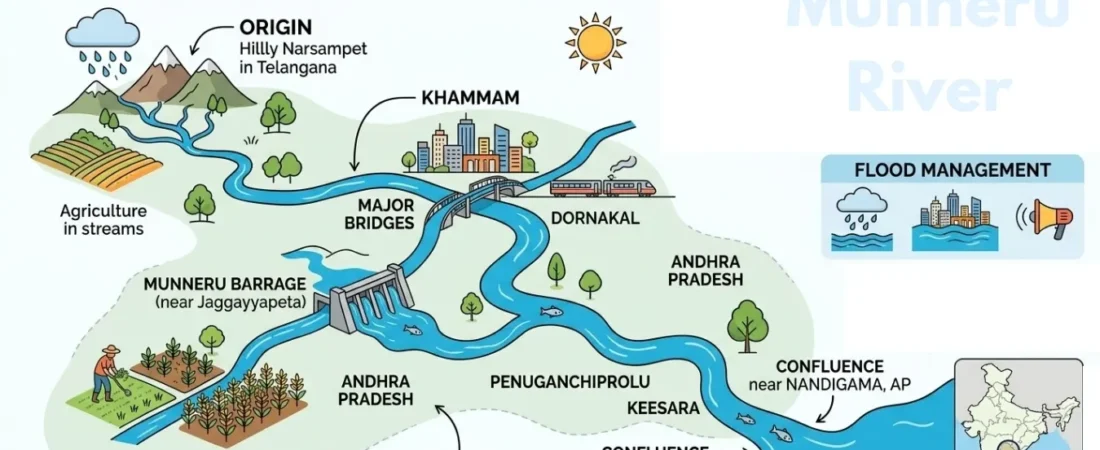
The Munneru River is a significant tributary of the Krishna River, flowing through parts of Telangana and Andhra Pradesh. Originating near the Narsampet region, it passes through important areas including Khammam before continuing toward its confluence with the Krishna near Nandigama. The river supports irrigation, agriculture, and local water resources across its basin, while its rising water levels during heavy monsoon rainfall can create serious flooding concerns for nearby communities. From its geographical course and historic bridges to the Munneru Barrage and cultural traditions, Munneru offers an interesting glimpse into the region’s natural and human landscape. This guide explores its origin, route, basin, importance, and key facts.
What Is the Munneru River?
Munneru is a left-bank tributary of the Krishna River and forms part of the wider Krishna River Basin. Unlike a small seasonal stream, its drainage network extends across a substantial area of Telangana and Andhra Pradesh.
The river has both environmental and economic importance. It contributes to irrigation and agricultural activity, shapes settlements along its course, and becomes particularly important during the monsoon when heavy rainfall can cause rapid changes in water levels.
Must Read: Lakaram Lake
Where Does the Munneru River Originate?
The river originates near the Narsampet region of Telangana, in the broader Warangal-area uplands. Rainfall and surface runoff from the surrounding catchment feed the upper reaches before the river develops into a more substantial watercourse.
The source is sometimes described differently in general online references because the upper catchment contains smaller streams and drainage channels. For a geographical overview, the Narsampet and Warangal region provides the clearest reference point for understanding its origin.
Course of the Munneru River
From its source region, the river travels generally toward the southeast through Telangana. Along the way, it passes through rural landscapes, agricultural areas, and settlements before continuing into Andhra Pradesh.
The river is associated with locations including Narsampet, Dornakal, Khammam, Penuganchiprolu, Keesara, and Nandigama. Its downstream course eventually reaches the Krishna River near Eturu, close to Nandigama.
Where Does the Munneru River Join the Krishna?
The downstream journey of the river ends when it joins the Krishna River near Eturu in the Nandigama area of Andhra Pradesh. This confluence connects the Munneru drainage system with one of India’s major river basins.
Its relationship with the Krishna is important for understanding the river’s geography. Water collected across the Munneru catchment ultimately becomes part of the larger Krishna drainage network, linking local rainfall and runoff with a much wider river system.
Must Read: Budget travel in India
Munneru River in Khammam
Khammam is one of the most important places associated with the river. The watercourse passes through the city and forms a prominent part of its physical landscape.
The river has practical importance for water resources, agriculture, transportation, and flood management around Khammam. Several bridges cross the river, helping connect communities and roads on either side.
Munneru River Basin
The river basin is the area from which rainfall and surface runoff drain toward the Munneru and its associated channels. It extends across parts of Telangana and Andhra Pradesh and forms part of the lower Krishna basin.
The basin is strongly influenced by agriculture, rainfall, land use, and human water demand. Research on the basin has also examined climatic conditions and water-resource requirements, showing that understanding the river requires looking beyond the main channel itself.
Munneru River Map and Location
A Munneru River map helps explain the river’s geography more clearly than text alone. The most useful map would show its approximate origin near Narsampet, its route toward Khammam, its movement into Andhra Pradesh, and its eventual connection with the Krishna.
Key locations such as Khammam, Penuganchiprolu, Keesara, Nandigama, and Eturu provide useful reference points. A map can also help readers understand how the river fits within the wider Krishna River Basin.
Major Tributaries and Drainage Channels
The Munneru drainage system is supported by smaller streams and channels that collect rainfall from the surrounding catchment. During normal conditions, these watercourses contribute to the river’s flow gradually.
During intense monsoon rainfall, however, runoff can increase quickly across the catchment. This is one reason the river’s water level can change rapidly during periods of exceptionally heavy rain.
Muniyeru Barrage and Irrigation
One of the notable structures associated with the river system is the Muniyeru Barrage near Jaggayyapeta. The historic irrigation structure was developed to help supply water to agricultural land and illustrates the long-standing importance of the river for farming.
Irrigation infrastructure allows available surface water to be directed toward cultivated areas. This is particularly significant in an agricultural basin where reliable water availability can influence crop production and rural livelihoods.
Agriculture Around the River Basin
Agriculture is a major land use across the wider basin. River water, rainfall, groundwater, and irrigation infrastructure work together to support farming communities in different parts of the catchment.
Common agricultural activity in the region includes crops such as paddy, cotton, and maize. The relationship between the river and agriculture is two-sided: adequate water supports cultivation, while excessive rainfall and flooding can damage fields and crops.
Must Read: Kambalakonda Wildlife Sanctuary
Major Bridges Across the Munneru River
Bridges are important parts of the river’s human geography. Crossings around Khammam and other settlements allow roads to pass over the river and connect communities on opposite banks.
These bridges become particularly significant during the monsoon. When water levels rise, transportation can be disrupted, making the condition of river crossings and surrounding roads an important part of local flood preparedness.
Why Does the Munneru River Flood?
Flooding is one of the most significant challenges associated with the river. Heavy monsoon rainfall across the upper catchment can generate large volumes of surface runoff that reach the river within a relatively short period.
The problem becomes more serious when intense rainfall occurs across several parts of the basin at the same time. Rapidly rising water can affect low-lying settlements, agricultural fields, roads, bridges, and riverside communities.
Munneru River Floods and Khammam
Khammam is particularly important when discussing flood risk because of its close relationship with the river. During major rainfall events, the river can rise substantially and affect areas near its banks.
Flood impacts depend on rainfall intensity, upstream runoff, river capacity, drainage conditions, and the location of settlements. Monitoring river levels and rainfall, maintaining drainage systems, and providing timely warnings are therefore important elements of flood preparedness.
Climate and Water Resources
Rainfall is one of the most important factors controlling the river’s flow. Seasonal monsoon precipitation can contribute substantially to surface runoff and recharge within the wider basin.
At the same time, changing land use and increasing demand for water can place additional pressure on river resources. Effective basin management, irrigation planning, flood monitoring, and sustainable water use are important for maintaining a balance between human needs and natural river processes.
Historical and Cultural Significance
The river has a traditional connection with Rishi Maudgalya, a sage mentioned in local religious traditions. According to the traditional account, the river’s name is associated with the sage and his spiritual activities in the Khammam region.
This story should be understood as a cultural and religious tradition rather than a scientific explanation of the river’s origin. Such traditions nevertheless form part of the cultural identity associated with the river and its surrounding communities.
Why Is the Munneru River Important?
The river is important because it connects several aspects of the regional environment and economy. It contributes to the Krishna drainage system, supports irrigation, influences agriculture, and provides a natural geographical feature around which settlements have developed.
Its importance is also visible during extreme weather. The same catchment that supplies valuable water can produce severe runoff during intense rainfall, making flood resilience and water management essential for communities along the river.
Places Associated With the River
Several towns and settlements provide useful reference points when tracing the river. Khammam is especially significant because the river passes through the city, while Penuganchiprolu, Keesara, and Nandigama are associated with its downstream course.
Visitors exploring the region can also combine their river-related journey with nearby historical, religious, and natural attractions. The river is best understood as part of a broader regional landscape rather than as an isolated tourist attraction.
Must Read: Shamirpet Lake
Munneru River: Quick Facts
| Feature | Details |
| River name | Munneru |
| River type | Tributary |
| Main river | Krishna River |
| Tributary position | Left-bank tributary |
| Origin region | Narsampet area, Telangana |
| Important city | Khammam |
| States | Telangana and Andhra Pradesh |
| Larger basin | Krishna River Basin |
| Main significance | Agriculture, irrigation, and water resources |
| Major concern | Monsoon flooding |
| Important structure | Munneru Barrage |
| Downstream connection | Krishna River near the Nandigama region |
Conclusion
The Munneru River is an important part of the Krishna River system, linking the Narsampet region with Khammam and downstream areas of Andhra Pradesh. Its basin supports agriculture and irrigation while also facing monsoon flooding and water-management challenges. From its geographical course and Krishna confluence to its bridges, barrage, cultural traditions, and role in local communities, the river offers a complete picture of how natural water systems shape the region.
FAQ’s
Which river is Munneru a tributary of?
Munneru is a left-bank tributary of the Krishna River. It forms part of the wider Krishna River Basin and eventually contributes its flow to the Krishna.
What is the Munneru River Basin?
The Munneru River Basin is the catchment area from which rainfall and runoff drain toward the river and its connected channels. It extends through parts of Telangana and Andhra Pradesh within the broader Krishna basin.
Why does the Munneru River flood?
Flooding generally occurs when intense monsoon rainfall produces large amounts of runoff across the catchment. When incoming water exceeds the river channel’s capacity, water can spread into nearby low-lying areas.
Is the Munneru River important for agriculture?
Yes. Agriculture is an important activity across the wider basin, and irrigation and other water resources support cultivated land. At the same time, excessive rainfall and flooding can cause crop and infrastructure damage.
What is Muniyeru Barrage?
Muniyeru Barrage is a historic irrigation structure associated with the river system near Jaggayyapeta. It was developed to help provide irrigation water to agricultural areas and reflects the river’s long-term importance to farming.